Carrello della Spesa
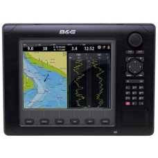
0 prodotto(i) - 0,00€ZEUS Z8"

- Very high brightness bonded screen SVGA (8" display) together
with LCD backlighting - Die-cast aluminium enclosure
- Waterproof to IPX7
- TimePlot shows user selected data history over time, ideal for assessing barometric pressure, depth or
wind speed trends - WindPlot provides a true wind speed and direction plot, allowing the sailor to make decisions on route choice, e.g. whether to tack or stand on, for fast and safe passage-making
- On-screen instrument panels display the user's choice of navigation
or instrument data in a
selection of formats - Polar tables entered for a design of boat to enable the crew to sail to the boat's optimum performance
The Display
At the core of the Zeus system lies a high specification multifunction display. Its powerful processor allows high speed access to a comprehensive range of capabilities, while a combination of direct access keys, keypad and rotary dial ensure that features can be activated, and data input and manipulated, in an easy and straightforward fashion.
Integrated Navigation System
The B&G Zeus display comes with an integral chartplotter with ultra-fast redraw and pre-loaded regional charts. Its in-built multifunction capabilities additionally equip it to act as a hub for a wide range of B&G and Navico instruments; displaying data in combinations, layouts and formats selected by the user, and allowing the full control and input of data.
Key features:
Full integration with B&G H3000 instruments
Direct integration with B&G H3000 instruments allows the B&G Zeus navigation software to assess the conditions using the most accurate data possible and enables the configuration of instrument functions. Features include:
- TimePlot shows user selected data history over time, ideal for assessing barometric pressure, depth or wind speed trends
- WindPlot provides a true wind speed and direction plot, allowing the sailor to make decisions on route choice, e.g. whether to tack or stand on, for fast and safe passage-making
- On-screen instrument panels display the user's choice of navigation or instrument data in a selection of formats
- Polar tables entered for a design of boat to enable the crew to sail to the boat's optimum performance.
Zeus supports B&G H-Link, NMEA0183 or NMEA2000 compatible instruments.
Charting
Integral chartplotter with preloaded cartography (Nautic Insight™ for the USA and Navionics coastal packages for Europe and APAC). A slot for SD cards allows the use of optional cartography including Navionics Platinum+ with 3D Turboview. Additional features include;
- Key sail navigation data overlaid onto premium embedded cartography
- Instant chart zoom with Rotary controller
- Easy navigation including goto cursor and goto waypoint along with straightforward route builder
- AIS and MARPA target overlay
- Radar overlay
- Dedicated sail navigation overlay
- Weather overlay
- New B&G Zeus GPS antenna (ZG50)
Radar, Sounders and much more
B&G Zeus will control and display data from a wide range of additional navigation instruments including:
- Broadband Radar
- HD radar
- AIS
- DSC VHF radios
- Pilots
- Echo sounders and fish finders
- SonicHub and other approved Ethernet, SimNet and NMEA2000 devices such as CZone Digital switching, StructureScan™, BSM-1 sounder and SIRIUS® satellite weather (US only).
Weather
The weather functionality of the B&G Zeus allows the user to view up-to-date forecasts overlaid on to the chartplotter and gain a clear understanding of the conditions that they are likely to face. Data supplied includes:
- Wind speed and direction
- Barometric pressure with pressure centre indicators
- Manual time step control – forward or back – to select any available forecast time
- Animation option shows how weather systems are likely to develop and allows the sailor to take appropriate steps to prepare, or route around
- Cursor Info feature allows quick assessment of the forecast at a particular location and time
- GRIB weather files can be easily uploaded via the USB port
Sail Navigation
The most important sailing data is overlaid onto the Zeus chart screen, enabling an assessment of the most efficient route to be sailed rather than a simple straight-line waypoint to waypoint route.
- Water and ground vectors show the effect of tide and leeway on the course
- Mark and boat layline positions are displayed with the user's choice of setting, ideal for assessing whether the boat will be able to clear a headland or obstacle on its next tack. This incorporates:
- Manual wind angle input
- Actual true wind angle from instruments
- Polar target wind angle from H3000 instruments
- Option to correct layline positions for measured tidal flow
Scrivi una recensione
Il Tuo Nome:La Tua Recensione: Nota: Il codice HTML non è tradotto!
Punteggio: Negativo Positivo
Inserisci il codice nel box di seguito:


