Il Tuo Carrello della spesa è Vuoto!
Tel. 0932.86.50.32
Fax. 0932.80.21.75
Carrello della Spesa
0 prodotto(i) - 0,00€ACCESSORI NAUTICI
MANUTENZIONE
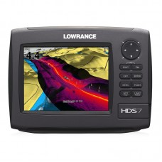
HDS-7 Gen2 No Tx
Codice Prodotto: HDS-7 Gen2 No Tx 000-10534-001
Disponibilità: 2 - 3 Giorni
Disponibilità: 2 - 3 Giorni
994,00€

Chartplotter/Ecoscandaglio
Nuovo chartplotter/ecoscandaglio con display a retroilluminazione LED ad alta luminosità, tecnologia Broadband Sounder™, antenna GPS integrata e mappatura ad alta definizione.
Caratteristiche Principali
- Massima rapidità
- In tempo reale StructureMap™ predisposizione
- Antenna GPS interna estremamente precisa
- Display ad alta luminosità visibile in pieno sole con retroilluminazione a LED.
- Funzione TrackBack™ per rivedere lo storico del sonar e salvare i waypoint sui punti chiave.
- Servizio Advantage 5 Years
Specifiche
| Panoramica | |
| Display | 6.4 in \ 163 mm 16-bit color Full VGA SolarMAX™ PLUS TFT |
| Resolution | Full VGA 480V x 640H |
| Operating Frequency | 50/83/200 kHz |
| Communication | NMEA 2000®, 0183 and Ethernet |
| Languages | 23 |
| Media Port | 1 SD/MMC slot |
| Warranty |
Two year |
| Display | |
| Display Resolution | 480 x 640 (H x W) |
| Display Type | 16-bit color Full VGA SolarMAX™ PLUS TFT |
| Display: Retroilluminazione | Screen/Keypad |
| Tipo Retroilluminazione | Pure white LED |
| Display Multi Lingua | Yes |
| GPS and Sonar Overlay Data | Yes |
| Presentazione Schermo Diviso | Yes |
| Display Size | 6.4 in \ 163 mm |
| Sonar | |
| Allarme Profondità | Yes |
| Frequenze ecoscandaglio | 50/83/200 kHz |
| Max Profondità Sonar Ecoscandaglio [m] | 1524 |
| FasTrack | Yes |
| Velocità Ping Hyperscroll | Yes |
| Allarme di Minima | Yes |
| Caratteristiche Standard Ricerca Pesce: COLORLINE™ o GRAYLINE®, ASP™, FishSymbol I.D.™, | Yes |
| Letture Temperatura | Yes |
| Tipo Trasduttore | Multiple selections for Lowrance® and Airmar® |
| Connettori di Rete | |
| Interfaccia NMEA 0183 | Type 422 [(1) Tx (1) Rx] |
| Connettori | NMEA 2000®, NMEA 0183 and Ethernet |
| Uscita NMEA | 0183/2000 |
| Tecniche/Ambientali | |
| Temperatura Funzionamento | (5F - 130F) (-15C - 55C) |
| Temperatura di Stoccaggio | (-40F - 185F) (-40C - 85C) |
| Memoria Interna di Back-up | Yes |
| Custodia |
Sealed and waterproof IPX7 |
| Product Width | 8.8 in \ 223 mm |
| Product Depth | 3.5 in \ 88 mm |
| Product Height | 6.5 in \ 164 mm |
| Alimentazione | |
| Consumo di Energia | 0.7A at 13 vDC with backlight on, 0.4A with backlight off |
| Alimentazione (Tensione di Alimentazione) | 10 - 17 vDC |
| Numero equivalenza Carico NMEA 2000 | 1 network load (50mA) |
| Comunicazioni | |
| Ingresso NMEA | Yes |
| Navigazione GPS | |
| Navigazione: Rotte | 200 |
| Navigazione: Salvataggio Waypoint | 5000 |
| Tipo Antenna GPS | Internal, high-sensitivity GPS+WAAS (Americas) or GPS+EGNOS+MSAS (non-Americas) |
| Man Overboard Feature | Yes |
| Plot Trails |
Up to 10 trails - up to 12,000 points/trail |
| Allarmi GPS | Yes |
| Custom Mapping |
Optional Lowrance Lake Insight™ HD, Lake Insight™ PRO, Nautic Insight™ HD, Nautic Insight™ PRO, Navionics Platinum+ and Platinum chartcards with Turboview™ for worldwide coverage - as well as Navionics® HotMaps Platinum, Fishing Hot Spots® PRO and legacy LakeMaster® Promaps |
| Background Mapping |
Expanded U.S. BaseMap or Insight USA™ (Americas) or Worldwide background map (non-Americas) |
| Altro | |
| Linguaggi | 32 |
| Potenza di Uscita [kW] | Max 250W Broadband, analog equivalent 30,000W and 32W Broadband, analog equivalent 3,750 W |
| Altre Caratteristiche | Performance Modules: StructureScan with optional LSS-1 module (8 color palette options), Broadband Sounder technology (with 14 color palette options), ethernet networking, optional SIRIUS Satellite Weather/Radio, Broadband Radar, Digital Radar, SonicHub |
| Capacità Scheda di Memoria |
One SD/MMC memory card slot |
| Radar | |
| Tipo Antenna | Optional Lowrance radar choices available |
Scrivi una recensione
Il Tuo Nome:La Tua Recensione: Nota: Il codice HTML non è tradotto!
Punteggio: Negativo Positivo
Inserisci il codice nel box di seguito:


