Il Tuo Carrello della spesa è Vuoto!
Tel. 0932.86.50.32
Fax. 0932.80.21.75
Carrello della Spesa
0 prodotto(i) - 0,00€ACCESSORI NAUTICI
MANUTENZIONE
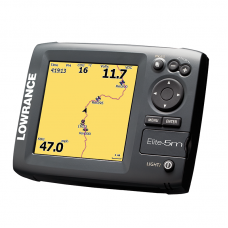
Elite-5m Baja

Il chartplotter a colori Baja Elite-5m offre ottime prestazioni di navigazione e colori intensi per le vostre gite outdoor, ad un prezzo molto conveniente. Un chartplotter outdoor dotato di pacchetto GPS+EGNOS+MSAS con un luminoso display a colori di facile visualizzazione.
Caratteristiche Principali
- Carta base Stati Uniti integrata
- Interamente caricata con caratteristiche GPS e funzioni con menu semplificati
- In grado di salvare 3.000 waypoint, 100 rotte e 100 percorsi memorizzabili
- Progettazione tastiera per utilizzo semplice con una mano
- Alloggiamento scheda media microSD
- Include kit con montaggio in-dash FM-ME5
- Include antenna esterna LGC-16W
Specifiche
| Panoramica | |
| Display | 5 in./12.7 cm SolarMAX PLUS Color |
| Resolution | 256 color TFT 480 x 480 |
| Waypoint Management | Up to 3,000 |
| Communication | NMEA 0183 |
| Languages | 23 |
| Media Port | One (1) MicroSD slot |
| Operating Voltage | 10-17 vDC |
| Warranty | One year |
| Display | |
| Display Resolution | 480 x 480 |
| Display Type | 256-color SolarMAX™ PLUS TFT |
| Display: Retroilluminazione | Flourescent cold cathode |
| Livelli Retroilluminazione | Adjustable screen/keypad |
| Display Size | 5 in \ 127 mm |
| Tecniche/Ambientali | |
| Memoria Interna di Back-up | Yes |
| Standard Impermeabilità | Sealed and waterproof, suitable for saltwater use |
| Product Width | 6.9 in \ 174 mm |
| Product Depth | 2.5 in \ 63 mm |
| Product Height | 5.4 in \ 136 mm |
| Alimentazione | |
| Alimentazione (Tensione di Alimentazione) | 10-17 vDC |
| Navigazione GPS | |
| Canali Ricevitore GPS | 16 |
| Navigazione: Rotte | 100 |
| Navigazione: Salvataggio Waypoint | 3000 |
| Tipo Antenna GPS | Internal high-sensitivity plus external LGC-16W module, both with WAAS correction |
| Plot Trails |
100 retraceable plot trails/up to 10,000 points per trail |
| Allarmi GPS | Yes |
| Custom Mapping |
Optional Navionics® Gold chartcards (U.S. & worldwide) and Fishing Hot Spots® and LakeMaster®* mapcards (U.S.) in microSD format |
| Background Mapping |
U.S. basemap with over 3,000 enhanced lake maps with depth contour and shoreline detail, plus coastal depth contours/shoreline detail and spot depth soundings to 1,000 ft./305 m |
| Connettori di Rete | |
| Uscita NMEA | NMEA 0183 |
| Altro | |
| Linguaggi | 23 |
| Capacità Scheda di Memoria |
One (1) waterproof microSD card slot |
Scrivi una recensione
Il Tuo Nome:La Tua Recensione: Nota: Il codice HTML non è tradotto!
Punteggio: Negativo Positivo
Inserisci il codice nel box di seguito:


